
Features 台灣山岳識別 - AR認山頭工具
This program can only run on devices that support Google AR service (ARCore).
Please refer to the ARCore support list listed by Google:https://developers.google.com/ar/devicesGenerally speaking, older mobile phones do not support ARCore, but even the latest mobile phones may not support it.
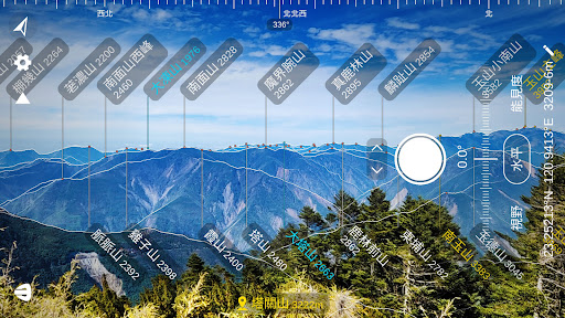
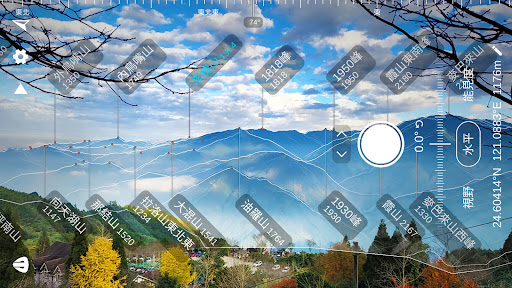
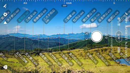
This may be because the mobile phone manufacturer is applying for ARCore certification from Google and may still support it in the future after it is approved.● Main features• From Baiyue to Jiaoshan, this program has collected more than 5,000 peaks in Taiwan• Use high-precision grid numerical terrain data for rendering, which is close to the real mountain contours• Intuitive operation, just drag the screen to adjust the azimuth and elevation angle• No need to be connected to the Internet, can be used completely offline● Professional version features• Take a photo: Take a photo of the mountain scene together with the name and outline of the peak and save it to your phone’s photo album• No ads: Remove the ads below to make the screen cleaner• Display altitude: Display the name of the peak together with the altitude, but some peaks have no altitude information• Mark Baiyue and Xiaobaiyue: Use different colors to mark Baiyue and Xiaobaiyue to facilitate mountain recognition.• More mountain peak information: Click on the mountain name to display the coordinates, distance...
and other related information of the mountain peak.• Customized GPS coordinates: After customizing the coordinates, you can view the mountains wherever you want to go● Precautions• This program uses image recognition to determine the rotation angle of the phone.
When the texture of the lens is unclear, or the scene moves too fast, the rotation of the viewing angle cannot be recognized, which may cause the screen to jump or stop.• Move your phone as slowly as possible when using it.
It cannot be used at night, in dense fog, or in a moving vehicle.
If you find that the mountain outline of the screen has shifted during use, you need to readjust the orientation.• Outlying island areas have not yet supported Penghu, Kinmen and Matsu• For your safety, please stand at a fixed point to use this app and do not look at the screen while walking• All the information in this program comes from open platforms on the Internet and may contain errors or incomplete information.• This program can only run on devices that support Google AR service (ARCore)
Social Features
Connect and share with friends and the community.
Gaming Features
Enjoy immersive gaming experience with various game modes.
Camera Features
Advanced camera features with editing capabilities.
See the 台灣山岳識別 - AR認山頭工具 in Action
Get the App Today
Available for Android 8.0 and above